Construction of the new bypass by Birse Civils is now well underway. The three mile route runs from the Harden roundabout and rejoins the existing A34 to the south of Nether Alderley village. The video below, produced by Birse as part of the tender process, provides a birds-eye view of how the bypass will look when it is complete.
As can be seen in the video, significant areas of landscaping have been designed to mitigate views of the new road and provide new wildlife habitats. These include over 20 hectares of new woodlands, trees, shrubs, streams, ponds and meadows. Displaced earth will be used to create mounding along the route, to hide the road and also reduce noise levels. The construction programme is also designed to maximise reuse of materials on site, including existing road surfaces, peat and topsoil which will help minimise the amount of construction traffic on local roads.
From Monday the 22nd of June Brook Lane will be closed for up to six weeks to accommodate sewer diversions and tie the temporary diversion into the existing road to enable the building of the new bridge over the bypass. There will be a signed diversion route via the Kings Arms roundabout in Wilmslow to redirect traffic.
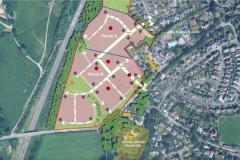
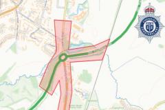
To provide you with an understanding of the route taken by the bypass we have produced the interactive map below. Click and drag to move around the map or use the directional arrows in the top left of the map. You can zoom in with a double left-click on the point of interest and zoom out with a double right-click. You can also zoom in and out using the [+] and [-] buttons in the top left of the map.
Once complete the bypass will hopefully go a long way to relieving the congestion caused by the 26,000 vehicles that currently pass through Alderley Edge daily. It is scheduled to open in the Summer of 2011.
If you would like to know more about the bypass there is a drop in information surgery every Wednesday, 9am-10:30am at the Sossmoss Lane site office (via the one way system, Nursery Lane).
Small print: Whilst every effort has been taken to ensure the interactive map is as accurate as possible we cannot be held liable for any inaccuracy. The map was created by digitally tracing the plan made available on the website of Cheshire East Council.


Comments
Here's what readers have had to say so far. Why not add your thoughts below.
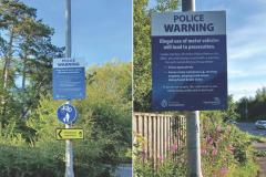
1. Single Carriageway - its all the government would approve. (Hence my opposition to the Dobbies development with its 400 place car park at the end of the bypass - insufficient capacity)
2. No junctions with Brook Lane or Chelford Road in order to prevent rat running along the country lanes
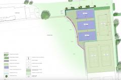
3. The planting schemes shown here are representative only - the final planning app for this element is about to be submitted. If you are near to the bypass you should check the planting that is intended to protect you and be prepared to comment.
Regards
Marc