Following the recent heavy rain, Cheshire East Council is investigating what can be done to prevent two major local roads from flooding every time we suffer periods of heavy rain.
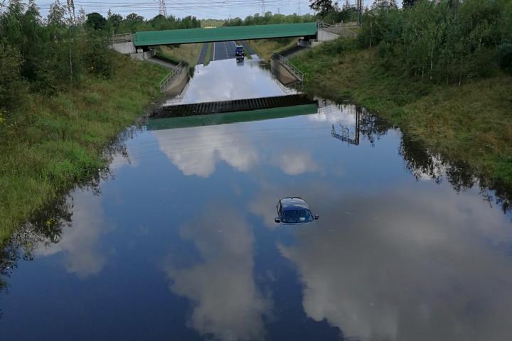
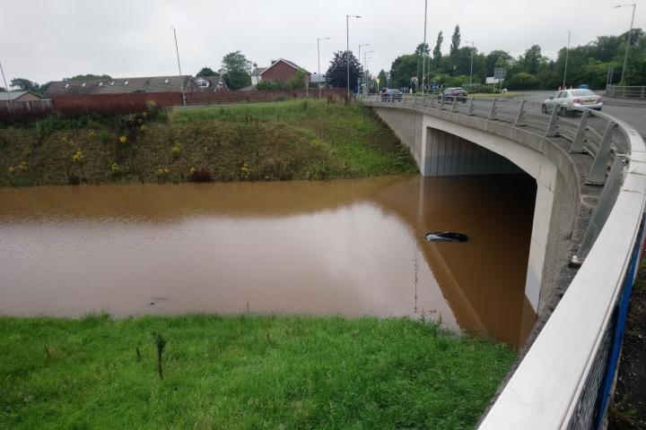
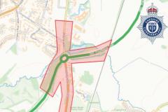
The £290m A555 Manchester Airport Relief Road, which opened in October 2018, and the £52m Alderley Edge Bypass (Melrose Way), which opened in November 2010, have both been closed on several occasions in recent months due to flooding.
Members of the Environment and Regeneration Overview and Scrutiny Committee were provided with an update on the flood recovery works being carried out at their meeting on Monday, 11th November.
Cheshire East Highways have been investigating the cause of the problems on the new airport relief road and Melrose Way, both of which were closed in July, October and, most recently, last week.
These investigations include an utilities survey, environmental survey and pump assessments. They have also been looking at proposed enhancement work and are awaiting approval following the completion of pump assessments.
Paul Traynor, head of highways at Cheshire East Council, told committee members "Both roads are designed to what is effectively your current design standards, but clearly they are not a one in 30 year storm.
"We are now looking at what enhancement we can take to cope with this volume of water and the volumes they are being asked to discharge."
He added "They are ongoing, it is a process."
Cllr Peter Groves said "We spent a huge amount of time and money dealing with potholes, and we have seen a substantial reduction in half year claims for damage, in light of the flooding should we now be concentrating on gulley clearing and dealing with flooding. Certainly we now see more complaints about dealing with blocked gullies than we do about potholes."
So far Cheshire East Highways have cleared 6672 gullies across Poynton, Adlington, Bollington and Ketleshulme. They have 1024 remaining in their recovery schedule to be completed by the end of November in Wilmslow, Handforth, Prestbury, Mottram St Andrew, Rainow, Pott Shrigley, and Lyme Handley.


Comments
Here's what readers have had to say so far. Why not add your thoughts below.
Shouldn't the insurance companies of the civil engineers or engineering firms that advised on these designs foot the bill? - and get on with it quickly.
These are probably the two newest major roads in the area that we waited years for and now every time there is a significant rainfall there not usable. Its hardly an unforeseeable circumstance.
This flood event in XXX years is unscientific crystal ball gazing. Get some engineering brains to sort out the problem along the following lines:
Florida gets lots of rain that mostly comes in sudden downpours. To disperse such sudden quantity of water by pumping directly off the roads would require a very high capacity pumping system [expensive too] with the danger that if a pump broke down the roads would not be cleared and flooding would result. Solution? Have an array of 'ponds' in the lower areas of land adjacent to the roads where water initially flows off the road surface and then pump it away over time - some of which is after the downpour has passed. These 'ponds' are interconnected so that if a pump fails the water can flow to another 'pond' and be dispersed by the pumps operating there.
The problem with the Alderley bypass is that the section of road in question is lower than the surrounding area in order to pass under the railway. I think it was decided not to go over the rail line so as to minimise the noise levels over in Alderley Edge. So the road sits in a ‘pond’ that cannot perhaps be emptied by the pumps, as they do not have the capacity to cope with a large downpour - or have become downgraded as a result of blockage or partial failure. A solution therefore is to dig a big hole to act as a ‘pond’ in the area next to where this flooding will occur in a heavy downpour and install several pumps that can still cope to empty the ‘pond’ even though half of them become incapacitated. Such a ‘pond’ will act like a reservoir or buffer zone to take the excess water off the road whilst the downpour is happening and prevent flooding on the road. The only factor to decide is the size of the ‘pond’ and a satisfactory array of pumps [plural] to empty it. A decent barrier to prevent vehicles falling into the ‘pond’ would also be a good idea. Had this concept been designed into the bypass when it was built the soil from the pond might not have been needed to be taken very far as it could possibly have been used on another part of the road construction.
PS: All this talk about withstanding "1 in XXX-year flood events". I can't help noticing that these recent floods prove that the roads haven't withstood anything! My definition of withstanding = not being affected by or carrying on as normal. What is your definition?