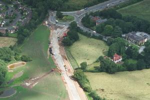
A planning application that was submitted on behalf of Birse and Cheshire East, proposing changes to the Alderley Edge and Nether Alderley bypass, has been recommended for approval this month by the Strategic Planning Board, subject to conditions.
The application (09/1582W) relates to proposed amendments to the A34 bypass which was granted planning approval in December 2003. (application 03/1846P).
The proposals include: mitigation earthworks mounding, re-profiling the fields adjacent to Wilton Crescent, amendments to bridge details, drainage pumping stations, relocation of ponds, amendments to carriageway levels and the construction of a footbridge over the bypass, connecting to Footpath 33 in Nether Alderley.
A number of objections were received from the Nether Alderley Rural Protection Association, The Nether Alderley Parish Council and local residents of both Sand Lane and Wilton Crescent.
Alderley Edge Parish Council raised concerns regarding noise levels, drainage detail and proposed that restrictions be placed on the hours of work being carried out around the Wilton Crescent area.
Other objections received related to the level of screening provided for local properties, headlight intrusion and loss of privacy as a result of the proposed changes to carriageway levels. Residents from Sand Lane also requested that the landscaping incorporates a 60% evergreen mix in order to provide the best possible mitigation in the winter season.
Following a meeting of the Strategic Planning Board on October 21st a decision was deferred in order for a site inspection to be carried out.
Following the inspection a second meeting was held on November 11th when the issue was declared resolved with the application to be approved subject to conditions which include greater levels of evergreen planting, protection for trees, breeding birds and roosting bats, restrictions on the hours of operation, noise and dust levels as well as protecting the highway from mud and debris.
A decision notice is yet to appear on the planning portal but we would assume this is just a formality.


Comments
Here's what readers have had to say so far. Why not add your thoughts below.
For example "mitigation earthworks mounding". What is this? Where is it to take place? I ask the same questions about "amendments to carriageway levels". Where? Higher...lower?
At least point us in the direction of where the information can be had please if you cannot be more specific in the article.
If you want to share anything from looking through the documentation please feel free to post a follow-up comment.