Yellow lines are 'unenforceable'

photo

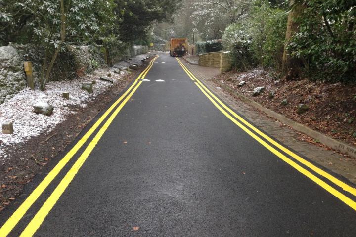
Double yellow lines and speed bumps have been installed on a private road in the Alderley Edge Conservation Area.

The yellow lines were painted on the top part of Woodbrook Road, as you turn off Macclesfield Road, on Friday, 15th February, by a contractor who said he was working for the owner of an adjacent property.

As the road is unadopted it is not maintained by Cheshire East Council but their Highways Department are seeking advice regarding whether the lines and speed bumps need to meet certain criteria.

Cheshire East Council have confirmed that the lines are unenforceable, as there is no Traffic Regulation Order, and the work is being examined by the northern area enforcement team of the Council.

Philip Jobling, from the Edge Association, said "Whilst we welcome investment in road maintenance, there was nothing fundamentally wrong with this stretch of Woodbrook Road and what has been done is not in keeping with what we would want to encourage. Had we been consulted we would have expressed our concerns."

Photo shows the top part of Woodbrook Road which has been resurfaced and had double yellow lines and speed bumps installed. These are only present on this top stretch, the road remains untouched as you turn the corner to head down into the village.

What do you think about the yellow lines and speed bumps installed on this section of Woodford Road? Share your view via the comment box below.

Tags:
Alderley Edge Conservation Area, Edge Association, Woodbrook Road
Advertisement
Advertisement
Advertisement
Advertisement

Comments

Here's what readers have had to say so far. Why not add your thoughts below.

Joy Daglish
Tuesday 19th February 2013 at 3:10 pm
I have no particular comment to make on whether double yellow lines are appropriate or not... but this is another case of when is a road private or not? Swill Hill has at various times by various departments within the council been "a designated highway", a "private road" and an "unadopted road". Each designation has been given at various times over the last 20 years and usually when it best suits parties unwilling to take responsibility for whatever the problem is at the time. So heavy vehicles can use Swiss Hill following their sat nav and we aren't allowed (even at our cost) to install weight restriction signs - but it's not a public highway? When said heavy vehicles cause the gas mains to rupture (after all this road wasn't made for 10 ton trucks) it's a highway to be repaired after the gas leak was fixed. Initially the bin men wouldn't drive up as the refuse dept said it was a private road and we should wheel bins to the bottom of the hill... at which point it was agreed it's a "designated highway". But no so much of a highway that the council will clear the leaves when the bin truck can't get here for risk of skidding on the leaves! Rant over... !
Sarah Lane
Tuesday 19th February 2013 at 3:20 pm
Sounds like a homeowner who does not want anyone parking near his/her home. Who had the road resurfaced if it's a private road. Did anyone park along that stretch of road anyway. The yellow lines look very out of place. Seems like someone just doing as they please.
Richard Bullock
Tuesday 19th February 2013 at 6:53 pm
It's not an adopted road, but what slightly muddies the water is that both Swiss Hill & Woodbrook Road are both public rights of way (on foot) - and therefore technically public highways (along with all other public footpaths). So the council as the local highways authority are responsible for the surface of the road in terms of making sure it is safe to use on foot. Interestingly, it might mean that the road humps themselves might be unlawful obstructions, presumably put up without consent of the council?
Marc Asquith
Tuesday 19th February 2013 at 9:05 pm
The road has been improved by a damn townie who came to live out on the edge of countryside.....

Next he / she will be installing street lights along the road side ....
Craig Wilson
Wednesday 20th February 2013 at 8:35 am
Marc ......... LOL!

The yellow lines will dull down and get dirty, so will not stand out as much very soon. Looks fine to me.
Matthew Lloyd
Wednesday 20th February 2013 at 9:41 am
Looks hideous and totally inappropriate to me. Such urbanisation of the Edge is surely against the spirit (at the very least) of the Conservation Area.
Sarah Lane
Wednesday 20th February 2013 at 10:29 am
Not having any need to go up that road I was just wondering if there was any need for double yellow lines. Do people park along that stretch of road? Speed humps and yellow lines do seem a tad OTT Can homeowners just get away with doing this? All seems very strange to have so much going on.
Joy Daglish
Wednesday 20th February 2013 at 11:53 am
In my opinion putting tarmac over historic cobbles which are in keeping with the environment and location, is a travesty.
Derek Stevens
Wednesday 20th February 2013 at 1:04 pm
If private road owners decide to have their road adopted by the council the council will insist, at the owners expense, to have it made up to current highway standards. This would mean tarmacing, kerb stones and correct drainage. And of course they could enforce parking restrictions like double yellow lines.Actually thinking about it ,Woodbrook Road, in it's old state, was more like some of the road surfaces in the district at the moment!!
Katherine Lloyd
Wednesday 20th February 2013 at 1:46 pm
Everyone seems to be missing the point.

Putting aside the fact that Penn is Grade II listed and, as such there are rules protecting its ‘setting’, this amounts to ‘vandalism’ and if ignored and allowed to go unchallenged, is a worrying precedent in the Alderley Edge conservation area.

Below are just a few relevant comments from the document itself:

THE ALDERLEY EDGE CONSERVATION AREA APPRAISAL
Planning (Listed Buildings and Conservation Areas) Act 1990 obliges local planning authorities to determine which parts of their areas are of special architectural or historic interest and to designate them as conservation areas. Section 72 of the same Act also specifies that it is the general duty of local planning authorities, in the exercise of their planning functions, TO PAY SPECIAL ATTENTION TO THE DESIRABILITY OF PRESERVING OR ENHANCING THE CHARACTER OR APPEARANCE OF THESE CONSERVATION AREAS.

THE CHARACTER AND APPEARANCE OF THE ALDERLEY EDGE CONSERVATION AREA
General description
4.1  The Alderley Edge Conservation Area is notable for its cohesive, sylvan qualities. Prestigious, detached villas, mostly dating to between 1845 and 1900, sit in generous plots with mature tree planting largely hiding them from the public viewpoint. STONE SETTED ROADS, stone boundary walls, the mature shrubs and large trees, and the undulating topography provide an interesting and unique townscape.
The conservation area is bounded by the busy Congleton Road to the west, and the more secondary Chapel Road/Mottram Road to the north. Macclesfield Road, another main route eastwards, bisects the conservation area and is notable for the hill rising from the village of Alderley Edge. OTHER ROADS ARE QUIETER AND MORE RURAL IN CHARACTER, PARTICULARLY SWISS HILL AND WOODBROOK ROAD.
For the front boundaries, hedging is often combined with a low stonewall and in Whitebarn Road, the stone walls have huge pieces of stone, practically still in situ, forming the base of the walls. A similar feature occurs in Woodbrook Road, with the naturally occurring rock forming the base of the high stone walls where the road cuts through the crest of the hill. THESE WALLS LOOK PARTICULARLY ATTRACTIVE WHERE THE ORIGINAL 19TH CENTURY SETTS HAVE BEEN RETAINED.
THE SETTED ROADWAYS WITHIN THE CONSERVATION AREA DATE TO THE 19TH CENTURY AND ARE PARTICULARLY NOTICEABLE IN WOODBROOK ROAD, WHERE THEY COMBINE VISUALLY WITH THE STONE WALLS WHICH UTILISE THE SAME, LOCAL SANDSTONE.
However, some improvements are needed to the roads, pavements and grass verges. The predominant material is tarmacadam and IN A MORE RURAL CONSERVATION AREA, SUCH AS ALDERLEY EDGE, THIS IS NOT INAPPROPRIATE.

THE FUTURE MANAGEMENT OF THE ALDERLEY EDGE CONSERVATION AREA
Local Plan policies
7.1  MACCLESFIELD BOROUGH COUNCIL IS COMMITTED TO PRESERVING AND ENHANCING THE CHARACTER OF THE ALDERLEY EDGE CONSERVATION AREA AND this appraisal should be read in conjunction with the Macclesfield Local Plan 1997 (as amended by the Local Plan 1st Alterations dated October 2000 and by the 2nd Alterations dated January 2002).
7.2  Policy BE12 states that in the Alderley Edge Conservation Area:
THE BOROUGH COUNCIL WILL SEEK TO PRESERVE AND ENHANCE:
THE WINDING SETTED LANES.
7.10 THE SETTED CARRIAGEWAYS MUST BE PROTECTED AND REPAIRS CARRIED OUT USING MATCHING MATERIALS.
Sarah Lane
Wednesday 20th February 2013 at 3:08 pm
Perhaps it's a major celeb and they have tarmaced the road to protect their 4x4 from having to drive on a rough road surface and the yellow lines are to stop the paparazzi from parking and taking close ups through the bushes. :)

I can't imagine the traffic warden making a special trip to Woodbrook Road to ticket any cars that might be parked on those lines. It seems like its impossible to sort out the illegal parking thats happening in AE itself so what hope for up that road. Unless of course they are employing their own traffic warden.
Tim Hardingham
Thursday 21st February 2013 at 12:05 pm
I agree wholeheartedly with Joy on the need for greater clarity on who has responsibility for what on Swiss Hill, Woodbrook etc. Ther is a need to control the heavy trucks up Swiss Hill, but its unclear if the residents can take the lead. With regard to yellow lines and speed bumps this is blatent disregard for "a conservation area" and all that implies. It looks rediculous and entirely out of place, as others have commented. Lets hope they can be removed if no planning approval was sought.
Trevor Leech
Saturday 23rd February 2013 at 7:50 am
Has anyone also noticed what the same person has done to the mature hedge and trees
alongside the path leading to the forest?
Frank Keegan
Saturday 23rd February 2013 at 1:56 pm
Not only does it look ugly, it is a breach of the whole spirit of Conservation. Dr Longworth was Chairman of the Edge Association for many years and lived on the left going into Woodbrook at that point, and he would have described this as "vandalism". I have referred the matter to Planning Enforcement to take action against this urbanisation of a special area.
Katherine Lloyd
Saturday 23rd February 2013 at 4:30 pm
Well done!

It is a travesty what has been done to that end of Woodbrook Road. The person that did this has scant regard for conservation and obviously more money than discernment.
Craig Wilson
Saturday 23rd February 2013 at 4:53 pm
Katherine, I wouldn't say 'well done' just yet. Q lots of running rings round the council!

Joy Daglish, if you want to see historic cobbles, come have a look at them on Davie Lane, the Tarmac is so bad on that road, there's plenty to look at. :-)
Giles Watmough
Sunday 24th February 2013 at 2:34 am
why bother, it's a private road and so not our concern surely? A discreet notice saying "Private Road No right of way" would have done the trick though, wouldn't it?
Peter Doff
Monday 25th February 2013 at 7:47 am
This man has organised the laying of about 100 yards of tarmac, lets put him in charge of repairing the roads around the village,might get something done.
Jon Williams
Monday 25th February 2013 at 10:43 am
Don't know what all the fuss is about, great bit of road to walk or cycle along now, shame the others down the road don't follow.