A report detailing the proposed changes to the Cheshire East Local Plan Strategy, including the new and amended strategic sites has been published.
The report requests that Council, Cabinet and the Strategic Planning Board approves these proposed changes to the Local Plan Strategy, alongside the Habitats Regulations Assessment (HRA) and Sustainability (Integrated) Appraisal for public consultation.
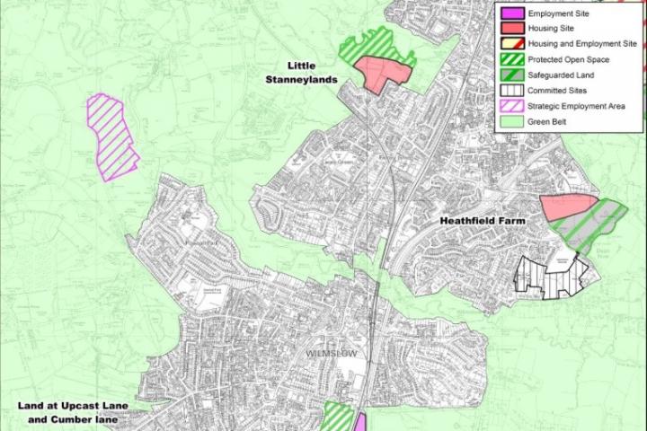
The recommended selection of sites in Wilmslow are:
The Spatial Distribution proposes that 900 homes be provided in Wilmslow along with 10 ha of Employment land (an increase from 400 homes and 8 ha in the submitted plan). As at 30 September 2015, there had been 87 net housing completions within the plan period and commitments totalled 312 units.
The one area of safeguarded land from previous Local Plans (land at Adlington Road) has now obtained consent and is under construction. Therefore to meet future needs additional allocations are proposed, all of which require amendment of the Green Belt boundary.
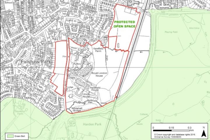
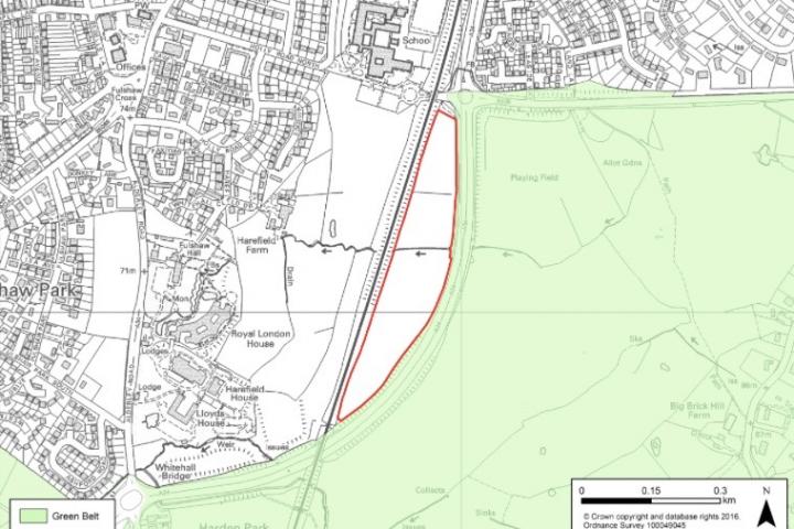
It is proposed to maintain the allocation at Royal London for mixed use but to include land west of Alderley Road within the developable area. This will now provide for around 175 homes (around 80 on land to the east of the existing campus, around 20 to the north of the existing campus and around 75 on land west of Alderley Road). The provision of 5 ha of employment land and a hotel. Plus the provision of at least 1 ha of land set aside for use as school playing fields within the site (in addition to the areas marked as open space on the map in the report).
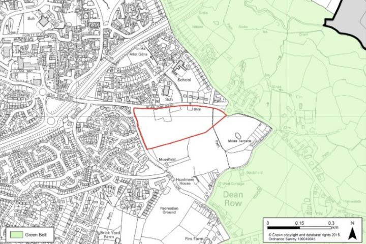
Further housing allocations are now proposed at Little Staneylands and Heathfield Farm. The former will accommodate around 200 homes on land off Stanneylands Road, situated adjacent to the Dean Valley. Allocation of this site will require an adjustment to the Green Belt boundary
Heathfield Farm at Dean Row Road is located on the eastern edge of the town and could accommodate around 150 homes. It will be accessed by the existingroundabout. The remainder of this land; extending to some 9 ha towards Cross Lane will be safeguarded for future development after the end of the plan period. Allocation of this site will require an adjustment to the Green Belt boundary.
A further area of safeguarded Land is proposed between Upcast Lane and Cumber Lane. This extends to approximately 15 ha.
Finally, it is proposed once again to allocate land west of the A34 close to Wilmslow High School for employment use. Wilmslow Business Park will provide up to 6.3 ha of employment land. Allocation of this site will require an adjustment to the Green Belt boundary.
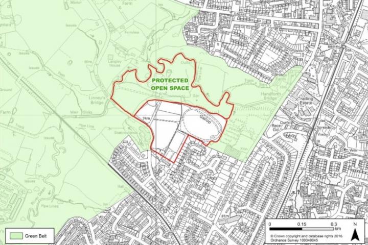
The recommended selection of sites in Handforth are:
The Spatial Distribution proposes that 2,200 homes be provided in Handforth along with 22 ha of Employment land. As at 30 September 2015, there had been 63 net housing completions within the plan period and commitments totalled 322 units. Employment land Commitments total nearly 10Ha.
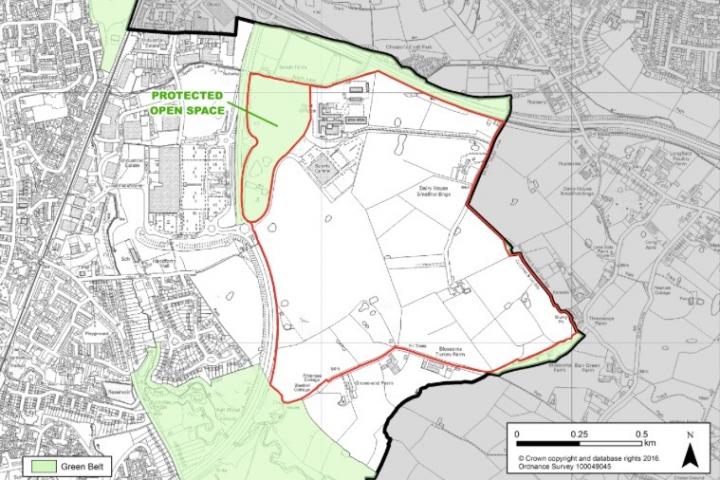
At the North Cheshire Growth Village, the site is located off the A34 Bypass and bordered to the north by the A555 (Manchester Airport Eastern Link Road), it is proposed to maintain the allocation of some 1650 homes, plus up to 12 ha of employment land. Allocation of this site will require an adjustment to the Green Belt boundary.
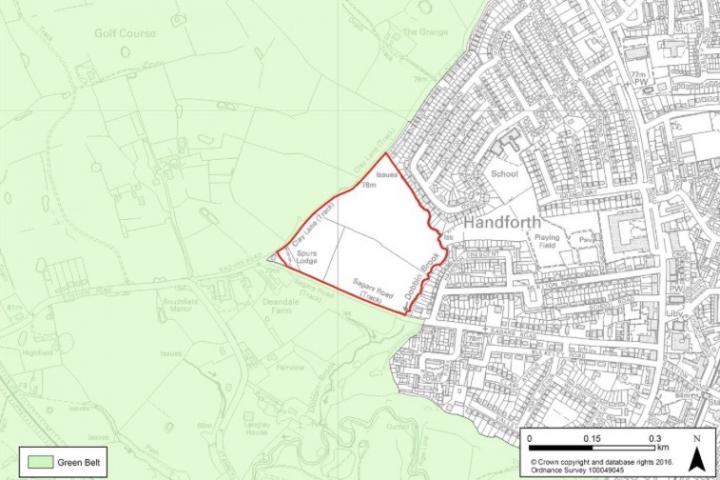
In addition, a further new site is proposed west of the town. Land between Clay Lane and Sagars Road is recommended for around 250 homes. Allocation of this site will require an adjustment to the Green Belt boundary.
14ha of land south of the Growth Village is also proposed for safeguarding – for development after 2030.
Once approved, it is recommended that the 'Cheshire East Council Proposed Changes to the Local Plan Strategy' be subject to full public consultation for a period of six weeks. This is provisionally set between 4th March and 19th April 2016, depending on the decision made on 26th February 2016.
All responses received will then be logged and assessed following the close of consultation. Once analysed, consideration will be given as to the need for further proposed changes to be made to the Local Plan Strategy as a consequence of the representations made. After this assessment is complete, all consultation responses, together with the Proposed Changes will be submitted to the Local Plan Inspector, Mr Stephen Pratt. It is then anticipated that the Examination Hearings will resume in September 2016.
The full report, which extends to over 700 pages, can be dowloaded from the Cheshire East Council website. The section covering Handforth starts on page 400 and the section on Wilmslow begins on page 496.
Cheshire East Council is seeking approval of the proposed changes at a meeting of Strategic Planning Board on 18th February, a meeting of Cabinet on 23rd February and the Full Council on 26 February.
Wilmslow Maps: Royal London Site, Wilmslow Business Park Site, Land at Little Stanneylands and Heathfield Farm.
Handforth Maps: North Cheshire Growth Village Site, Land Between Clay Lane and Sagars Road.


Comments
Here's what readers have had to say so far. Why not add your thoughts below.
There is a stunning lack of clarity in the above summary without downloading the full report which (it boasts) extends to over 700 pages.